.JPG)
 On the left here is the Greenway track - attractive but not an option this time. It comes up later on as you'll see.
So, squaring our cold shoulders and cheeks against the freezing wind, we headed towards the Royal Docks down Prince Regent Lane to the station. As we reached it, the wind blasted us again - the open water between us and the City Airport making us much colder than before.
I could sense this would be a bit of a battle and it was. The aeroplane noise was tremendously powerful and we walked as fast as we could to reach shelter. We were heading east for the landmark Beckton pumping station at the end of Custom House Road to then turn north towards Barking Creek. Unfortunately, we couldn't walk north at all - the road was blocked so we had to hop a train to go the one stop to Beckton and then turn east again towards Barking Abbey. Coming out of Beckton Station on to Woolwich Manor Way, things got a bit confusing.
Despite this, I found Beckton quite a pleasant, upbeat and regenerated place, with allotments and nice houses so we prayed blessing and walked on. By now our feet were a little sore and we were quite hungry! But we pushed on towards the Greenway, hoping to cut across a large part of the area direct to Barking Abbey. It didn't work out quite like that as the Greenway stopped in the middle of Beckton and despite the map, didn't continue to Barking.
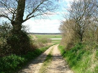
The right hand photo is of  Rob at the other end of the
 Rob at the other end of the
 Greenway. You can see it's become a little dilapidated although many cyclists still use it in the summer.
At this point, we needed an angelic encounter because we were becoming lost - after this exit point, the path wound around and around and not only did we lose our sense of direction, we couldn't see anything due to high trees. So we prayed and God came through. A couple of German(!) cycle tourists turned up and explained how to get back to the main road we needed.
After paying a visit to the McDonalds there, we pushed on seeking our way out of the paths to Barking Abbey. After some more prayer, the Lord led us to a rubbishy tatty hidden path that ended in Jenkins Lane, the original road we had thought would take us to Barking Abbey - a totally God-arranged appointment because even with map and compass, there was no doubt we were still lost.
Jenkins Lane is an original old road running along the edge of East Ham just to the left of the A1020 (later the A406) and alongside the sewage works. The Lord led us directly to the only footbridge that crosses that road into Barking and without realising it, had taken us right alongside the Creek - all the way up.

The photo to the left here is the single footbridge that crosses the A13 below.

The photo to the right is the A13 as it goes off into Essex.
Below is the sluice gate at Barking Creek. I believe it also acts as a floodgate. These are essential around the Thames and at the moment, many are being repaired due to fear of the Thames flooding. I encountered many floodgates as I did later walks along the Thames into Essex.

You can see some of the old trawlers on Barking Creek. It used to be one of the largest fishing ports in Southern England and a local man, called Samuel Hewett, born in 1797, founded the Short Blue Fleet (England's biggest fishing fleet) based in Barking, and using smacks out of Barking and east coast ports.
Short Blue Fleet used gaff ketches which stayed out at sea for months, using ice for preservation of fish. I believe he was the first man to use ice for freezing fish.
Sharon Stone (http://www.cieurope.org/) visited Essex in July 2005. She prophesied over Barking:
God will apply the heat of his spirit to melt the icehouse – melt the frozen assets.
He will release buildings to your purposes. Be thawed, Barking!
New community standards will bring new community – removal of mistrust. Unity will come out of diversity. God will expose threatening areas in the community and secret whispers will be exposed. There will be no secret aggression against the church – put your Watchmen on the Wall!
(From notes taken at the meeting by Jane Almond)
Lord, we pray for this word not to fall to the ground and for it to be fulfilled. Melt the frozen assets, Lord. Be thawed, Barking...put your Watchmen on the Wall! Let the fish jump into the boats!
Rob and I moved on into Barking and the first thing we spotted was a stone henge formation in the gateway. Three stone shapes formed a half-henge as below, with words carved in each of the stones.
 I couldn't read them all but some words on them were as follows: "A circle of stone, an island of grass beside the Roding. An old iron gate leading to the Abbey ruin, stepping into history." Then on the next one: "Gulls soar over the icy water....smell the sea...see the ...." and the last one "Barking Town quay ghost fishing fleet." The stone circle seems to have been created to commemmorate Barking's past as a prominent and successful fishing port. I prayed here that Barking's future would come into alignment with God's destiny for it.
By this time, we were within photo distance of the site of the Abbey which itself no longer exists except for the gate tower - a significant remnant. In its place is St Margaret's Church where Captain Cook was married in 1762 - a man who took advantage of gateways created by the British empire.


The photo (left) is of St Margaret's Church today. It holds the gateway into Barking and East London, being strategically positioned right alongside the Creek.
The other photo (right) is of the 1560 reconstruction of the Abbey gatehouse through the trees of St Margaret's churchyard. A stone rood within the tower of the reconstructed gateway was an object of pilgrimage in medieval times. I would suggest the stone rood was the reason for the reconstruction of the gateway as pilgrimages were fairly lucrative for the church - this was prior to the changes wrought by the Reformation, after which such pilgrimages were less popular.
As to its general history, the manor of Barking was the site of Barking Abbey, a nunnery founded in 666 by Eorcenwald, Bishop of London. It was destroyed by the Danes and reconstructed about a hundred years later in 970 by King Edgar. William the Conqueror stayed there after his coronation in 1066. In 1539, during the dissolution of the monasteries by Henry VIII, Barking Abbey was dissolved and demolished.
Rob and I finished our walk by returning to the station, warmed by latte and tea. A good walk through east London and a greater understanding of it in context as part of Essex.


1 comment:
Last weekend I tried a similar walk to you - although I wanted to go south beside Barking Creek from the A13. Google earth clearly shows a walkway to the west of the creek, however every road and path I took ended up at big uninviting pointy metal fences.
I too ended up on Jenkins Ln, and then at the McDonalds, then walked round and round in circles, finally finding the end of the Greenway like you also - and yet another metal fence.
Oh well, next time I'm going to try walking North form the A13 up the creek, and will be looking for some of the landmarks you've got in your photos.
Best regards and thanks for the information.
Matthew
darnkitty.com
Post a Comment